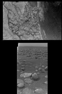
To me it looks like Huygens landed on a cobble-strewn tidal flat! Where are the seaweed and the crabs, the fishing boats and the puffy clouds?
And those valleys, morphologically stubby, usually signify sapping of some sort (with runoff not principally from 'rainfall'), but sapping of what from what is unclear. I thought it was too warm for liquid methane: am I wrong? Ethane or propane, anyone? Porous ice filled with liquid hydrocarbons? When, or does, it rain?
There's some signs of wind erosion too, from the photos last July. What is the role of the wind in shaping the landscape? Is wind more important than rain (unlike Earth)? What are the Saturnian tides like? Does the slow rotation rate make a difference?
And why does it look like the fluids flow away from the 'ocean', rather than into it? Doesn't look like a delta to me (unlike what others have said): more like a decaying a highland area, but am I wrong? Is the 'bedrock' turning rotten from years of sapping, with some fluids flowing in, and others flowing out?
Such a great place to land - so lucky that the area is a transitional zone, and not just one type or the other, not just 'land' or 'ocean'! I always thought the pictures from last July showing the general Huygens landing area vicinity on Titan looked suspiciously like the Mediterranean, with the actual landing spot somewhere in Greece. Here we are in a new cradle of civilization!
No comments:
Post a Comment