
Albuquerque International Sunport.

I've never seen the hill at Tome (Belen?) and the Ladron Mountains line up so well before, but that's probably because you have to be nearly at the intersection of the two runways to see it so well.

Rio Bravo Blvd. and I-25 interchange.

SW of the South Valley tank farm.

Second St. and the railroad.

Sandia Mountains.

Rio Grande River and Bridge Blvd.

Rio Grande River and Bridge Blvd.

Rio Grande High School.

Master-planned development on the city's southwest side.

Curious, this West Mesa terrain.

I-40 and Central Ave.

KOAT TV Doppler radar.

The crest between the Rio Grande and Rio Puerco watersheds.

The Rio Puerco River.

Approaching To'hajiilee. Canada de los Apaches.

To'hajiilee. Sandoval Canyon and Mesa Gigante.

To'hajiilee. Sandoval Canyon and Mesa Gigante.

To'hajiilee. Sandoval Canyon and Mesa Gigante.

To'hajiilee. Sandoval Canyon and Mesa Gigante.

Cerro de la Celosa, Moquino, Seboyeta, Bibo, Paguate.

Flank of Mt. Taylor: Wheat Mountain, lava flows.

Flank of Mt. Taylor: New Laguna, lava flows.

Flank of Mt. Taylor: Encinal Canyon, Paraje Mesa, lava flows.

Flank of Mt. Taylor, looking ENE. Lava flows.

Entire southern flank of Mt. Taylor.

Near Cubero. Paraje Mesa; looking ENE.

The distant, magical-looking Cerro Alesna. I need to go there some day.

Acomita Lake/ Skyline-Ganipa.

McCartys. Horace Mesa, Tafoya Canyon.

Mt. Taylor.

Between McCartys and Grants. Horace Mesa, McCarty Mesa, McCarty.

Along State Road 117. Las Ventanas Ridge, El Malpais.

Bonita Canyon, Gallo Peak, San Rafael Mesa.

Mine on State Road 53, near Tinaja.

Mine on State Road 53, near Tinaja.

South of El Morro Rock. Ramah Navajo Indian Reservation.

Southwest of El Morro Rock; El Morro. Ramah Navajo Indian Reservation.

North of Pine Hill. Ramah Navajo Indian Reservation.

State Roads 36 at McKinley County Line.

Southeast of Zuni.

Dowa Yalane, near Zuni. The residents of Zuni fled here when Coronado came to this area in 1540.

Ojo Caliente Reservoir.


 Rio Verde.
 Bartlett Lake.
 Fountain at Fountain Hills.
 Fountain at Fountain Hills.
 Beeline Highway.
 Red Mountain Freeway and North Alma School Rd.
 McDowell and Beeline Triple Junction.
 Pima Freeway - Scottsdale Boundary.
 Near N. Hayden and E. McKellips Rd.
 McKellips Lake.
 Priest Dr. and Washington St./ Papago Park Center.
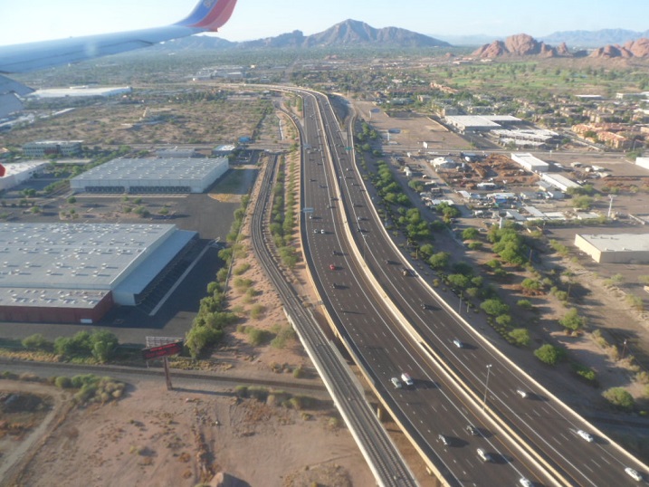 I-10.
I-10. Sky Harbor.
 Sky Harbor.
 Sky Harbor.
 Sky Harbor.
 Sky Harbor.
 I-10.
I-10. Downtown Phoenix.
 North Central.
 Near Black Canyon Freeway and W. Carefree Highway/ AZ Game and Fish headquarters.
 Through the murk, and after sunset, Lake Tahoe.
 Albuquerque International Sunport.
 I've never seen the hill at Tome (Belen?) and the Ladron Mountains line up so well before, but that's probably because you have to be nearly at the intersection of the two runways to see it so well.
 Rio Bravo Blvd. and I-25 interchange.
 SW of the South Valley tank farm.
 Second St. and the railroad.
 Sandia Mountains.
 Rio Grande River and Bridge Blvd.
 Rio Grande River and Bridge Blvd.
 Rio Grande High School.
 Master-planned development on the city's southwest side.
 Curious, this West Mesa terrain.
 I-40 and Central Ave.
 KOAT TV Doppler radar.
 The crest between the Rio Grande and Rio Puerco watersheds.
 The Rio Puerco River.
 Approaching To'hajiilee. Canada de los Apaches.
 To'hajiilee. Sandoval Canyon and Mesa Gigante.
 To'hajiilee. Sandoval Canyon and Mesa Gigante.
 To'hajiilee. Sandoval Canyon and Mesa Gigante.
 To'hajiilee. Sandoval Canyon and Mesa Gigante.
 Cerro de la Celosa, Moquino, Seboyeta, Bibo, Paguate.
 Flank of Mt. Taylor: Wheat Mountain, lava flows.
 Flank of Mt. Taylor: New Laguna, lava flows.
 Flank of Mt. Taylor: Encinal Canyon, Paraje Mesa, lava flows.
 Flank of Mt. Taylor, looking ENE. Lava flows.
 Entire southern flank of Mt. Taylor.
 Near Cubero. Paraje Mesa; looking ENE.
 The distant, magical-looking Cerro Alesna. I need to go there some day.
 Acomita Lake/ Skyline-Ganipa.
 McCartys. Horace Mesa, Tafoya Canyon.
 Mt. Taylor.
 Between McCartys and Grants. Horace Mesa, McCarty Mesa, McCarty.
 Along State Road 117. Las Ventanas Ridge, El Malpais.
 Bonita Canyon, Gallo Peak, San Rafael Mesa.
 Mine on State Road 53, near Tinaja.
 Mine on State Road 53, near Tinaja.
 South of El Morro Rock. Ramah Navajo Indian Reservation.
 Southwest of El Morro Rock; El Morro. Ramah Navajo Indian Reservation.
 North of Pine Hill. Ramah Navajo Indian Reservation.
 State Roads 36 at McKinley County Line.
 Southeast of Zuni.
 Dowa Yalane, near Zuni. The residents of Zuni fled here when Coronado came to this area in 1540.
 Ojo Caliente Reservoir.


