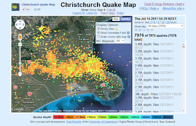
 I didn't know about this "Snip" utility on Windows 7 that has apparently replaced screen shots. I got excited about "Snip" when I learned about it today, because now I could finally capture the map on this Web Site, showing Christchurch quake epicenters.
 In particular, I was interested in ALL Christchurch quakes since September 4th of last year. In addition to the main faults being made manifest by densely-packed rows of dots, some of the subsidiary faults make a ghostly appearance too. You just need a large enough sample of quakes to see these other faults!
Several main features are evident on the map. The original Greendale Fault, of course, with its western fork, with one branch snaking west and the other branch heading towards Darfield. Then the subsequent extension eastwards: The Port Hills Fault, which seems to stop abruptly just offshore. But then there is a ghostly line of dots heading south, along the western shore of Lake Ellesmere. And the southeastern spear of dots through Akaroa, which intersects the Port Hills Fault and then continues northwestward until it reaches a vertex at the base of the mountains.
The faults seem to define a triangular shard of the northern Canterbury Plains where quakes are fewer in number. Based on the literature, this triangular shard appears to be rotating counterclockwise.
Christchurch quakes are unusually shallow. Compared to most places, the rock that is being shattered here is cold and brittle. The Canterbury Plains are like a shattered, rotating porcelain plate, with the various shards rubbing against each other. Why did it shatter in quite this way? Who can say?
No comments:
Post a Comment