Here are several pictures from a set making the rounds on the Internet. I put in a request to see who took these pictures, when, and from where. Now, my second-hand contact says they aren't from Hurricane Katrina at all, but from Iowa in 2004. But it's still quite vague, the details on these shots. Nevertheless, I don't care that much: it's the photos themselves that speak volumes.
One advantage of (having once lived in) the dry American Southwest is that thunderstorm cloud base is usually so high that the storm clouds can often be seen in great, picturesque detail. Even though storm clouds east of the Mississippi River are typically much larger, cloud base is so low that they often can't be seen clearly, and so the effect isn't as picturesque.
With a big storm (or a hurricane), violent, humid updrafts are located very close to drier, violent downdrafts. With good visibility provided by a low sun angle (this is presumably near sunset), the effect is to allow great views of amazingly violent processes - much better than what you see even in the American Southwest.
As a meteorologist, I have to say these are the best pictures of 'wall clouds' I've ever seen. Wall clouds are the wall-like clouds that appear to be lower than typical cloud deck. They are caused by violent updrafts of very humid air, air that is more humid than its immediate surroundings, but which is moving upwards so rapidly that it doesn't have time to mix with its immediate, drier surroundings. In violent thunderstorms, wall clouds usually signal big trouble - the location from where funnel clouds will descend. The drier, descending air all around the wall cloud permits the wall cloud to be seen. In fact, I never imagined wall clouds could have such clearly-visible vertical extents as these wall clouds do!

Here she comes!

You open the Venetian blinds, see a skyscape like this, and all you want to do is shut the blinds!

Awesome wall cloud!
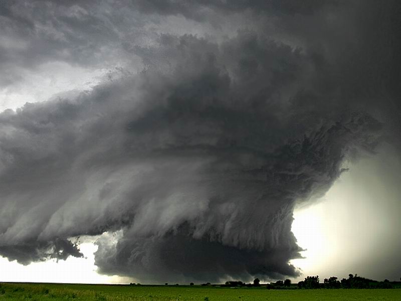
A better view of the awesome wall cloud!

The sky is looking increasingly ominous......
Storm Pictures, Attributed!
Aha! Those fabulous storm pictures are indeed from the Midwest!:
Storm chaser Mike Hollingshead hasn't been paid or given credit for the photos that have appeared in the Netherlands, Canada, Australia and Brazil, among other places. Furthermore, the photos of tornadoes in Nebraska, Kansas and Iowa are being passed off as Hurricane Katrina pictures.
Many people received the photos in their inbox. They've been sent thousands of times. Hollingshead has link after link on his Web site to all of the other sites, chat rooms and e-mails where his pictures have appeared.
The pictures were mostly taken in 2004. All were snapped within a few hundred miles of Omaha.
Hollingshead takes the pictures for a living, and about nine months ago, he started getting e-mails from other storm chasers telling him his pictures were appearing around the world.
"People started selling them to magazines like Weatherwise, then a Dutch magazine about weather, then to newspapers and TV shows," Hollingshead said.
He said he tried to correct the Web sites, but it just kept spreading.
No comments:
Post a Comment