Let me know if you have any problems or questions (E-Mail address: valdezmarc56@gmail.com).
--------------------------

"A Guidebook To 'Breaking Bad' Filming Locations: Including 'Better Call Saul' - Albuquerque as Physical Setting and Indispensable Character" (Sixth Edition)
Purchase book at the link. This book outlines thirty-three circuits that the avid fan can travel in order to visit up to 679 different filming locations for "Breaking Bad" and "Better Call Saul" in the Albuquerque area. Some background is provided for each site, including other movies that might have also used the site for filming.
"‘Breaking Bad’ Signs and Symbols: Reading Meaning into Sets, Props, and Filming Locations” (Second Edition)
Purchase book at the link. “‘Breaking Bad’ Signs and Symbols,” aims to understand some of the symbolism embedded in the backgrounds of “Breaking Bad” and “Better Call Saul,” in order to decode messages and stories Vince Gilligan and crew have hidden there. A series of tables are used to isolate how certain (particularly architectural) features are used: Gentle Arches, Tin Ceilings, Five-Pointed Stars, Octagons, etc. Daylighting innovations that were either pioneered or promoted in Chicago are examined: Glass Block Windows, Luxfer Prismatic Tile Windows, and Plate Glass Windows.
Certain symbols advance the plot: foreshadowing symbols like Pueblo Deco Arches, or danger symbols like bell shapes and stagger symbols. Other features, like Glass Block Windows or Parallel Beams in the Ceiling, tell stories about the legacies and corruptions of modernity, particularly those best-displayed at Chicago’s “Century of Progress” (1933-34).
To avoid unnecessary friction, I have redacted the addresses of all single-family homes in these books. (These addresses are still available at Marc Valdez Weblog, however.) The pictures in the print editions are black-and-white, in order to keep costs down.
"A Guidebook To 'Breaking Bad' Filming Locations: Including 'Better Call Saul' - Albuquerque as Physical Setting and Indispensable Character" (Sixth Edition)
Purchase book at the link. This book outlines thirty-three circuits that the avid fan can travel in order to visit up to 679 different filming locations for "Breaking Bad" and "Better Call Saul" in the Albuquerque area. Some background is provided for each site, including other movies that might have also used the site for filming.
"‘Breaking Bad’ Signs and Symbols: Reading Meaning into Sets, Props, and Filming Locations” (Second Edition)
Purchase book at the link. “‘Breaking Bad’ Signs and Symbols,” aims to understand some of the symbolism embedded in the backgrounds of “Breaking Bad” and “Better Call Saul,” in order to decode messages and stories Vince Gilligan and crew have hidden there. A series of tables are used to isolate how certain (particularly architectural) features are used: Gentle Arches, Tin Ceilings, Five-Pointed Stars, Octagons, etc. Daylighting innovations that were either pioneered or promoted in Chicago are examined: Glass Block Windows, Luxfer Prismatic Tile Windows, and Plate Glass Windows.
Certain symbols advance the plot: foreshadowing symbols like Pueblo Deco Arches, or danger symbols like bell shapes and stagger symbols. Other features, like Glass Block Windows or Parallel Beams in the Ceiling, tell stories about the legacies and corruptions of modernity, particularly those best-displayed at Chicago’s “Century of Progress” (1933-34).
In addition, a number of scenes in the show are modeled after Early Surrealist artworks. The traces of various artists can be tracked in both shows, including: Comte de Lautréamont, Giorgio De Chirico, Man Ray, Max Ernst, Leonora Carrington, René Magritte, Toyen, Yves Tanguy, Remedios Varo, Paul Klee, and in particular, Salvador Dalí.
--------------------------
Inaugurating Pluribus!
First, I list locations by episode. Then, I list locations by neighborhood, the way I have usually done for the other Vince-Gilligan shows.
Season 1 Filming Locations By Episode
Very Large Array (VLA) radio telescopes, San Augustin Plain west of Magdalena, NM (also used in the movie 'Contact,' starring Jodie Foster.
Bookstore - Barnes and Noble Bookstore, 6600 Menaul Blvd. NE, at Coronado Mall (FB friend Xandra was in the scene).
USAMRIID labs - CNM Rio Rancho campus, 2601 Campus Blvd. NE, Rio Rancho, NM.
ABQ Sunport - On landing, the view is looking northeast along SW/NE runway, towards the Sandia Mountains. Baggage collection and escalators at the ABQ Sunport are shown as well.
Sunport parking garage - Row I, Level 3. This parking garage is holy ground in the Gilliverse. Essentially, the parking garage itself is treated as a map of the ancient American Southwest, featuring the ancient Pueblo Meridian, represented by the interior, skylighted north-south open space within the garage. All parking-garage filming locations in BrBa, BCS, and Pluribus are chosen to be as close as possible to the skylighted open space, which represents the Pueblo Meridian (see my discussion here).
Vicinity of Bar - Vicinity of Vernon's Speakeasy, 6855 4th St. NW, where the 2013 Walter White burial plaque was eventually memorialized, and just a short distance from the El Camino Motor Hotel.
Police car - on Bobby Foster Rd., near "Q" Studios, where many "Breaking Bad" scenes were filmed.
Carol gazes over city on fire - Bobby Foster Rd, at almost exactly the same place where Kim Wexler has her car crash in "Better Call Saul."
Hospital Emergency Room - College and Career High School, 940 University Blvd. SE.
Zombie street scene - Approximately 1500 1st St. NW. Vicinity of Kinley Ave. and 1st St. NW.
Cul-de-sac where Carol lives - Roughly six houses on the slope of the JA Volcano (35.165335°, -106.746240°). I tried visiting there in February, 2025, but I could see that security was waiting for me, so I didn't visit.
Episode 102 - "Pirate Lady"
Islas Canarias (Canary Islands)
Approximate location of Car Crash - Las Palmas de Gran Canaria, Barranca Guiniguada (28.102771°, -15.429149°)
Zosia climbs on motorbike - up above from previous site? - C. Cruz de Piedra
Painted pavement - Calle Nilo (28.104666°, -15.422091°)
Near rug shop - ?
Motorbike descends towards port - C. Sierra Nevada (28.104243°, -15.424704°)
Coastal drive pedestrian overpass (28.067770°, -15.417158°)
Airport - In the Pluribus Facebook Group on Facebook, this location is claimed by the Belen Regional Airport, but the terminal looks mysterious to me. What is the model for the airport terminal? I don't know!
Cul-de-sac again
C-130 at Sunport - on landing, view looking northeast along SW/NE runway, towards the Sandia Mountains. Shower at Hotel (thinking Sandia Casino, but who knows?) I like how they are preparing Zosia's extensions in the scene.
Subdivision street - unclear. Possibly Retablo Rd. NW.
Crane - According to Frank Sandoval: "First Baptist Church on Paseo Del Norte east of golf course, north side of the building. They used the backside of the Baptist Church for the scene. 4101 Paseo del Norte Blvd NW, Albuquerque, NM 87114"
Driving on street - thinking around 9101 Retablo Rd. NW.
Cul-de-sac
Airport at Bilbao, Spain - According to Atlas of Wonders: The "establishing shot was filmed at the real Bilbao Airport in the Basque Country, designed by the renowned Valencian architect Santiago Calatrava. However, the interior was filmed at the Oviedo Congress and Exhibitions Center in Asturias, designed by the same architect."
Estate in northeastern Spain - Getaria, Basque Country - Iturregi Hotela, 20808 Askizu, Gipuzkoa, Spain.
Episode 103 - "Grenade"
Sprouts (interior) - According to Apple TV podcast, this is the old Sears Store at Cottonwood Mall, same as the location used for a department store in the "Better Call Saul" episode "Nippy."
Sprouts (exterior) - Sprouts Farmer's Market store #707, 13150 Central Ave. SE, 87123
Sprouts parking lot - Carol watches trucks approach not far away from the old Sears store location, over more by Dillards, where there is a better view of the Sandia Mountains, at (35.197336°, -106.655171°)
Hospital - CNM Westside Campus, 10549 Universe Blvd. NW.
Episode 104 - "Please, Carol"
Storage units and house in Paraguay - Interior is on set, according to Apple Podcast. Exterior, storage units in ABQ, off 4th Street, near Vernon's. Chamisa Self Storage, 7010 4th Street NW, Los Ranchos de Albuquerque. These place are all near the El Camino Motor Hotel, which was an important filming location in "Better Call Saul."
CNM Open Space?
Cul-de-sac
Hospital - CNM Westside Campus, 10549 Universe Blvd. NW.
Episode 105 - "Got Milk"
Hospital - CNM Westside Campus, 10549 Universe Blvd. NW.
House Interior
Crowne Plaza Hotel, 1901 University Blvd. NE, Albuquerque, NM.
(Rooftop built in studio)
Stairwell
City Vista as seen from top of the Crowne Plaza Hotel.
Cul-de-sac
Street corner - ?
Near playground - milk containers - ?
Duke City Dairy - According to Atlas of Wonders, this is La Cumbre Brewing Co., 3313 Girard Blvd. NE.
Cop car scraping bottom - ?
Builder Materials, 1707 Commercial St. NE. Carol picks up paving stones here.
Driving on the street
Sprouts at night -
Agri-jet (exterior) - Monumental Studios, 1235 Aspen Ave. NW.
Episode 106 - "HDP"
Agri-jet (exterior) - Monumental Studios, 1235 Aspen Ave. NW.
Westgate Hotel and vicinity, 3000 Paradise Rd. Las Vegas, NV. According to the Apple podcast, the gambling scene was set in Elvis' old bedroom there.
According to the Apple podcast, the John Cena presentation was filmed in Tampa, FL.
Storage Units - Chamisa Self Storage, 7010 4th Street NW, Los Ranchos de Albuquerque.
Lit street - I'm beginning to wonder if this is a studio shot. I'm having trouble finding such a location in Las Palmas.
Manousos talks with his 'mother' - Las Palmas de Gran Canaria. Intersection of C. Real del Castillo and C. Gobernador Marín Acuña (28.101797°, -15.423640°).
Episode 107 - "The Gap"
There are many locations in this episode, so it will take a while to get all the locations gathered. Many echoes from "Breaking Bad" and "Better Call Saul" are present in this episode.
Opening Scene - Good old Highway 4 leading into the Jemez Mountains from San Ysidro (35.575128°, -106.754926°)
Second Scene - approximately (35.641777°, -106.724987°)
Gas Station and Convenience Store - Red Rocks Convenience Store, which is also a filming location for the 2021 movie "The Marksman," starring Liam Neeson (35.643748°, -106.725261°). The interior of the store was not filmed here, maybe, in part, because the store interior is too small. We need to locate the interior location that was actually used!
"End of the World as We Know It" - (35.676265°, -106.738040°)
Back at the cul-de-sac.
Golf course at the Albuquerque Country Club (with the buffalo), and its parking lot, at 601 Laguna Blvd. SW, Albuquerque.(previously seen in "Better Call Saul," where Kim, Paige and Kevin, as well as Howard and Cliff, golfed).
Jemez Springs Sign (35.680691°, -106.737422°).
"Explode Into Space" - ?
Hot Spring (bringing back memories of Werner talking about wanting to visit hot springs in the Jemez Mountains in "Better Call Saul") - Jemez Hot Springs (formerly Giggling Springs), 40 Abousleman Loop, Jemez Springs, NM.
Old Albuquerque Library (formerly used for Davis and Main's lobby in "Better Call Saul").- Special Collections Public Library, Bott Hall, 423 Central Ave. NE, Albuquerque.
In the episode credits, Georgia O'Keeffe paintings are attributed to the collection at the Georgia O'Keeffe Museum, which is located at 217 Johnson St. in Santa Fe, NM. Nevertheless, the walls as pictured remind me of the Albuquerque Museum, 2000 Mountain Rd. NW, Albuquerque. I need to check my pictures to get a better sense of which museum they actually used. It is possible they constructed their own museum interior.
Cul-de-sac again
Carol's solo dinner at a fancy rooftop restaurant - Hotel Chaco, 2000 Bellamah Ave. NW, Albuquerque (previously visited by Lydia in "Better Call Saul").
Manousos on the Road
Manousos - Empty Gas Can (28.797610°, -17.785030°)
"How About Some Water?" (28.797640°, -17.785415°)
Driver Leaves (28.797550°, -17.785909°)
House with Spanish Tile Roof (28.796851°, -17.784307°)
Manousos on Bridge filmed from about here (28.796756°, -17.781169°)
Bridge - (28.797112°, -17.780979°)
Gilman Tunnels, Jemez Mountains - first view - (35.735451°, -106.764973°)
Gilman Tunnels, Jemez Mountains - second view - (35.734364°, -106.765050°)
Gilman Tunnels, Jemez Mountains - third view - (35.731900°, -106.764196°)
Argentine Village - Jemez Pueblo, looking towards western horizon. Probably located near northern edge of Pueblo. I can't quite figure this one out. Here is a candidate location that needs to be checked out in person (35.618718°-106.724684°).
Petroglyphs (on map, San Pedro de Atacama) - Looks like near Jemez Pueblo. The official podcast implies it may be on the opposite side of Highway 4 from the gas station. Candidate Location for Map (35.642693°, -106.723609°)
Highway 6, southwest of Albuquerque (34.892383°, -107.081808°)
Steep street - Calle Cardón, Tazacorte, La Palma (28.643501°, -17.932031°)
Seashore - ?
Gabinete Literario, Pt. de Cairasco, Las Palmas de Gran Canaria (28.102873°, -15.416567°)
Seaside Drive 1 - Kilometer 3 (28.089321°, -15.703299°)
Seaside Drive 2 - Manousos' car is at (28.091650°, -15.706444°)
Rain -
Seaside Village - Camino Bajada de Caleta, Gran Canaria (28.162603°, -15.681881°)
Church - Santuario de Nuestra Señora de Las Angustias - La Palma, Islas Canarias
Drive in city - ?
(on map, Huaquillas)
Tilos Bridge, La Palma - Manousos Drives (28.798464°, -17.777770°)
(The Girl Saves the Mouse from the Trap)
Waterfall - Cascada de Los Tilos
Hospital Perpetuo Socorro (HPS Private Hospital), C. Pdte Alvear, Las Palmas de Gran Canaria, Spain (28.137210°, -15.430486°)
Jungle - near Cascada de los Tilos?
Manousos sets car afire - Podcast says car was set afire in PECOS, of all places! The town and area of Pecos is generally the entrance to the Pecos Wilderness, the terminus of a number of trails. Presumably they are at one of those places.
Manousos collapses - Podcast says that Manousos collapses in Spain (presumably in the Canary Islands) but the helicopter arrives when he is in New Mexico.
Carol Golfs - BBVA, aka Compass Bank Building, at approximately (35.088529°, -106.652323°) - This building was previously used in movies like "The Last Stand" (2013) with Arnold Schwarzenegger and "The Take" (1974) with Billy Dee Williams. This building is diagonally across the intersection from City Hall, which was used numerous times in "Better Call Saul." Carol's golf balls land in the 500 Marquette Building.
Cul-de-sac fireworks (Call back to BCS episode "Lantern").
Samon's Home Improvement Center - Samon's Electric and Plumbing Supply, 5314 Central Ave. SW, Albuquerque.
Cul-de-sac
Episode 108 - "Charm Offensive"
Panamanian Hospital - Don't have this one yet.
Cul-de-sac
Arena - Rio Rancho Events Center, 3001 Civic Center Circle NE, Rio Rancho, NM 87144.
Cul-de-sac
Desert with train - This is quite a strange scene. Given the view of the Sandias in the distance in the scene, I suspect the overlook corresponds to an area previously-used at the beginning of "El Camino" - above the place where Mike dies in "Say My Name" in "Breaking Bad." Possible Overlook location is about (35.383992°, -106.502848°). The vista with the train in it, however, appears to me to be a digital creation of Rodeo in Montreal, and not a real vista at all. So, Carol and Zosia spend much of their conversational time gazing into large green screens rather than looking into the vast distance.
I can think of at least three reasons why they would want to create an artificial landscape rather than use the real one: 1.) There aren't many sufficiently-grand overlooks of railroad tracks in the Albuquerque area - there are some nice overlooks north of town near Lamy, or west of town near Mesita, but they aren't adequate; 2.) Landscapes might be recognizable from El Camino; and 3.)The actual vista from the overlook contains an area of religious sensitivity for Tamaya (Santa Ana) Pueblo. Since they are filming on Santa Ana land (possibly San Felipe land too, since the Pueblos are next to each other and their lands abut in this general neighborhood) they must avoid showing this sensitive area. They also avoided showing this sensitive area in "Breaking Bad," "El Camino," and "Better Call Saul." The Rodeo people in Montreal have been getting better and better over the years making digital desert landscapes that look suitable for the Albuquerque area, and this landscape is their best creation yet!
Swimming Pool - Podcast identifies this as Los Poblanos Historic Inn & Organic Farm, 4803 Rio Grande Blvd NW, Los Ranchos De Albuquerque, NM 87107
Sculpture and Telescope - Podcast says near the Rio Rancho Events Center. Sky Room Campus Park, 2516 King Blvd. SE, Rio Rancho, NM.
Crocquet in sports stadium - Milne Stadium, 1200 Hazeldine Ave SE.
Lauchlin's Coffee Shop - The former Whole Hog Café, 725 Central Avenue NE (and an homage to David Lynch's "Mulholland Drive). Several "Breaking Bad" and "Better Call Saul" filming locations are located not far away (e.g., Crossroads Motel, Grove Restaurant).
Cul-de-sac.
Underpass - This is the same underpass under University Blvd. used in Breaking Bad. It looks different than I remember, but the podcast says it's the same. I think the fascia of the underpass may have changed in the last 14 years. Coordinates: (35.008191°, -106.625973°)
Episode 109 - "La Chica o El Mundo"
Peruvian Village - This location is driving me nuts. The Official Apple Podcast states that this location is in the vicinity of Pecos, NM, but it's very hard to locate. All the mountain peaks are CGI, presumably by Rodeo in Montreal, so there aren't many reliable visual clues. And Pecos is a perfect warren of secret places. Still, it's important to resolve this location, because Manousos' journey is partly in pecos too. Based on a YouTube video of behind-the-scenes footage of the scene, I'm thinking (35.548253°, -105.667231°) is a possibility, but I'm not certain, because I would expect to see ground markings on the Google Earth image (taken shortly after filming would have ended), and I don't see anything.
Airstrip - I think this is the Moriarty, NM airport; specifically the western end, where the big "8" is painted on the tarmac (34.982262°, -106.016957°).
According to Atlas of Wonders, the swimming pool is at Iturregi Hotela, 20808 Askizu, Gipuzkoa, Spain, and the picture of towering rocks comes from Ha Long Bay, Vietnam.
Beach - ?
NYC - ?
Ski Lift Gondola - This is at the brand-new Explorer Gondola Base at the Big Sky Ski Resort in Montana (45.286008°, -111.402200°).
Ski Lodge Room - According to the Apple Podcast this place is a restaurant - "One and Only Moonlight Basin Restaurant," Big Sky Resort, 77 Roosevelt Rd., Big Sky, MT 59716 (45.322833°, -111.428575°).
Cul-de-sac
- - - - - - - -
My goal for the next sections is to first use my own photographs, and then to supplement them with screen-captures if I don't have suitable images.
New Mexico Filming Locations
Season 1 Filming Locations By Albuquerque Neighborhood
Northeast Heights (E. of Wyoming, W. of Juan Tabo, S. of Osuna)
(no new locations offered with this update)
Upper Northeast Heights (E. of Juan Tabo)
(no new locations offered with this update)
Northeast Heights (N. Of Osuna)
(No new locations offered with this update)
Lower Northeast Heights Locations (W. of Wyoming), & Lomas Blvd. Corridor

Bookstore - Barnes and Noble Bookstore, 6600 Menaul Blvd. NE, at Coronado Mall. FB friend Xandra was in the scene ("Pluribus," Season 1, episode 1, 'We Is Us').

Barnes and Noble Bookstore ("Pluribus," Season 1, episode 1, 'We Is Us').

Bookstore - Barnes and Noble Bookstore, 6600 Menaul Blvd. NE, at Coronado Mall. FB friend Xandra was in the scene ("Pluribus," Season 1, episode 1, 'We Is Us').

Bookstore - Barnes and Noble Bookstore, 6600 Menaul Blvd. NE, at Coronado Mall ("Pluribus," Season 1, episode 1, 'We Is Us').

Bookstore - Barnes and Noble Bookstore, 6600 Menaul Blvd. NE, at Coronado Mall ("Pluribus," Season 1, episode 1, 'We Is Us').
Downtown

Zombie street scene - Approximately 1500 1st St. NW. Vicinity of Kinley Ave. and 1st St. NW ("Pluribus," Season 1, episode 1, 'We Is Us'). Near the "Better Call Saul" Boxing Ring, 1512 First Street NW ("Better Call Saul," season 6, episode 5, 'Black and Blue').

Builder Materials, 1707 Commercial St. NE ("Pluribus," Season 1, episode 5, 'Got Milk'). Carol picks up paving stones here.

Carol Golfs - BBVA, aka Compass Bank Building, at approximately (35.088529°, -106.652323°) - This building was previously used in movies like "The Last Stand" (2013) with Arnold Schwarzenegger and "The Take" (1974) with Billy Dee Williams. This building is diagonally across the intersection from City Hall, which was used numerous times in "Better Call Saul" ("Pluribus," Season 1, episode 7, 'The Gap'). Carol's golf balls land in the 500 Marquette Building. Picture from 2024.
Downtown West and Old Town

Agri-jet (exterior) - Monumental Studios, 1235 Aspen Ave. NW ("Pluribus," Season 1, episodes 105 and 106, 'Got Milk' and 'HDP').

Agri-jet (exterior) - Monumental Studios, 1235 Aspen Ave. NW ("Pluribus," Season 1, episodes 105 and 106, 'Got Milk' and 'HDP').
 Hotel Chaco, 2000 Bellamah Ave. NW ("Pluribus," Season 1, episode 7, 'The Gap' - previously seen in "Better Call Saul," Season 4, episode 2, 'Breathe'). Carol's solo dinner at a fancy rooftop restaurant!
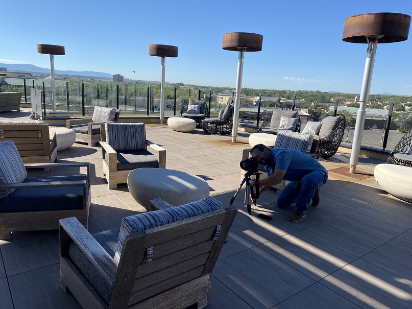
Rooftop photos, with James Gelet.


Huning Castle & ABQ Country Club
Golf course at the Albuquerque Country Club (with the buffalo), and its parking lot, at 601 Laguna Blvd. SW, Albuquerque.(previously seen in "Better Call Saul," where Kim, Paige and Kevin, as well as Howard and Cliff, golfed).


Albuquerque Country Club (photo from 2023)
Barelas
(no new locations offered with this update)
Huning Highlands/ Martineztown

Exterior of the building represented as the Georgia O'Keeffe Museum ("Pluribus," Season 1, episode 7, 'The Gap')In "Better Call Saul," this was the exterior of the Davis and Main Law Offices in Santa Fe. In actuality, this is the Special Collections Library, NM History and Archives, 423 Central Ave. NE, at the intersection of Edith and Central NE. I used to visit the Hispanic Genealogical Research Center (HGRC) here (but apparently it recently moved to the main library downtown). Until the mid-1970's it was the headquarters of the Albuquerque Public Library. I spent many hours here as a kid and as a teenager.
In the episode credits, Georgia O'Keeffe paintings are attributed to the collection at the Georgia O'Keeffe Museum, which is located at 217 Johnson St. in Santa Fe, NM. Nevertheless, the walls as pictured remind me of the Albuquerque Museum, 2000 Mountain Rd. NW, Albuquerque. I need to check my pictures to get a better sense of which museum they actually used, if they actually used a museum at all. It is possible they constructed their own museum interior.("Pluribus," Season 1, episode 7, 'The Gap')
 Lauchlin's Coffee Shop - Formerly Milton's Coffee Shop and more recently the Whole Hog Café, 725 Central Avenue NE (and an homage to the coffee shop in David Lynch's "Mulholland Drive). Several "Breaking Bad" and "Better Call Saul" filming locations are located not far away (e.g., Crossroads Motel, Grove Restaurant).

University Area & Near Presbyterian Hospital

Hospital Emergency Room - College and Career High School, 940 University Blvd. SE ("Pluribus," Season 1, episode 1, 'We Is Us').

Hospital Emergency Room - College and Career High School, 940 University Blvd. SE. Looking in the front window of this building, closed on a weekend ("Pluribus," Season 1, episode 1, 'We Is Us').

Hospital Emergency Room - College and Career High School, 940 University Blvd. SE ("Pluribus," Season 1, episode 1, 'We Is Us').

Hospital Emergency Room - College and Career High School, 940 University Blvd. SE ("Pluribus," Season 1, episode 1, 'We Is Us').

Crocquet in sports stadium - Milne Stadium, 1200 Hazeldine Ave SE ("Pluribus," Season 1, episode 8, 'Charm Offensive').
Nob Hill
(no new locations offered with this update)
South Valley (West of River), Southwest Albuquerque and Pajarito Mesa
(no new locations offered with this update)
San Jose Neighborhood and South Valley (East of River)
(no new locations offered with this update)
Southeast Heights
ABQ Sunport - On landing, the view is looking northeast along SW/NE runway, towards the Sandia Mountains. Baggage collection and escalators at the ABQ Sunport are shown as well ("Pluribus," Season 1, episode 1, 'We Is Us').

Escalator at the ABQ Sunport, featuring a display featuring Tim Keller, the Mayor of Albuquerque ("Pluribus," Season 1, episode 1, 'We Is Us').


Sunport parking garage - Row I, Level 3, Space 35. All parking-garage filming locations in BrBa, BCS, and Pluribus are chosen to be as close as possible to the skylighted open space, which represents the Pueblo Meridian (see my discussion here).

Looking towards the interior open space in the garage ("Pluribus," Season 1, episode 1, 'We Is Us').

Space 35 is the space.
C-130 at Sunport - on landing, view looking northeast along SW/NE runway, towards the Sandia Mountains ("Pluribus," Season 1, episode 2, 'Pirate Lady').

Zosia arrives at the Albuquerque Sunport. "C" gates. These gates are for regional airlines. To reach "C" gates DO NOT go through the security protocol upstairs. These gates are located on the ground level, so no escalator ("Pluribus," Season 1, episode 2, 'Pirate Lady').

Zosia arrives at the Albuquerque Sunport. They must have had a green screen here, to give the illusion of a long hallway ("Pluribus," Season 1, episode 2, 'Pirate Lady').

Sprouts (exterior) - Sprouts Farmer's Market store #707, 13150 Central Ave. SE ("Pluribus," Season 1, episode 3, 'Grenade Lady').

Sprouts (interior of the exterior location) - Sprouts Farmer's Market store #707, 13150 Central Ave. SE ("Pluribus," Season 1, episode 3, 'Grenade Lady').
Near "Q" Studios
 In Pluribus, Carol drives past here, where a police-car accident occurs at night. In "Breaking Bad." refrigerated-truck ambush scenes occur here ("Breaking Bad," Season 4, episode 4, 'Bullet Points', and episode 6 'Cornered'). These are familiar open mesa scenes near Q Studios, on Bobby Foster Rd. SE, about (34.986424°, -106.637737°). Photo from 2011.("Pluribus," Season 1, episode 1, 'We Is Us').
 Carol gazes over a city in flames. These trees are glancingly visible in the scene ("Pluribus," Season 1, episode 1, 'We Is Us'). This place is also where Jane & Jesse are reunited ("El Camino: A Breaking Bad Movie"). This is also the same location on Bobby Foster Rd. SE where Kim has her car accident ("Better Call Saul," Season 3, episode 9, 'Fall'), but the view in this picture is looking east instead of west. (34.989141°, -106.645636°). Photo from 2019.
  Underpass on Los Picaros Rd. at University Blvd. SE (35.008233°, -106.625899°). This is the same underpass under University Blvd. used in Breaking Bad. Photo from 2011.("Pluribus," Season 1, episode 8, 'Charm Offensive').
 Underpass, Los Picaros Rd. SE at University Blvd. SE (35.008233°, -106.625899°). Photo from 2011.("Pluribus," Season 1, episode 8, 'Charm Offensive').
"Q" Studios
These are studio locations, wherever they happen to be. Examples include:
Interior of the 747
Norwegian Ice Hotel
I-25 Corridor, North

Duke City Dairy - According to Atlas of Wonders, this is La Cumbre Brewing Co., 3313 Girard Blvd. NE ("Pluribus," Season 1, episode 5, 'Got Milk').

Crowne Plaza Hotel, 1901 University Blvd. NE, Albuquerque, NM.("Pluribus," Season 1, episode 5, 'Got Milk').
(Rooftop built in studio)
Stairwell
City Vista as seen from top of the Crowne Plaza Hotel.
North Valley

Storage units and Manousos' house in Paraguay - Interior is on set, according to Apple Podcast. The exterior are storage units in ABQ, off of 4th Street, near Vernon's. The address is: Chamisa Self Storage, 7010 4th Street NW, Los Ranchos de Albuquerque. These place are all near the El Camino Motor Hotel, which was an important filming location in "Better Call Saul" ("Pluribus," Season 1, episodes 4 and 6, 'Please, Carol' and 'HDP').

Vicinity of Bar - Vicinity of Vernon's Speakeasy, 6855 4th St. NW, where the 2013 Walter White burial plaque was eventually memorialized, and just a short distance from the El Camino Motor Hotel ("Pluribus," Season 1, episode 1, 'We Is Us').

Image of Al Capone.

Swimming Pool - Podcast identifies this as Los Poblanos Historic Inn & Organic Farm, 4803 Rio Grande Blvd NW, Los Ranchos De Albuquerque, NM 87107 ("Pluribus," Season 1, episode 8, 'Charm Offensive').
Northwest Albuquerque

Crane - According to Frank Sandoval: "First Baptist Church on Paseo Del Norte east of golf course, north side of the building. They used the backside of the Baptist Church for the scene. 4101 Paseo del Norte Blvd NW, Albuquerque, NM 87114" ("Pluribus," Season 1, episode 2, 'Pirate Lady').

Hospital - CNM Westside Campus, 10549 Universe Blvd. NW (First seen in "Pluribus," Season 1, episode 3, 'Grenade').

Interesting tunnel.

Where Zosia suffers heart failure.

Unfortunately I toured this site on a Saturday, and I could not enter most of the buildings of interest.

Sprouts (interior) - According to Apple TV podcast, this is the old Sears Store at Cottonwood Mall, same as the location used for a department store in the "Better Call Saul" episode "Nippy" ("Pluribus," Season 1, episode 3, 'Grenade').

Sprouts parking lot - Carol watches trucks approach not far away from the old Cottonwood Mall Sears store location, over more by where Dillards is, where there is a better view of the Sandia Mountains, at (35.197336°, -106.655171°)("Pluribus," Season 1, episode 3, 'Grenade').
Rio Rancho

Arena - Rio Rancho Events Center, 3001 Civic Center Circle NE, Rio Rancho, NM 87144 ("Pluribus," Season 1, episode 8, 'Charm Offensive').

Sculpture and Telescope - Podcast says near the Rio Rancho Events Center. Sky Room Campus Park, 2516 King Blvd. SE, Rio Rancho, NM ("Pluribus," Season 1, episode 8, 'Charm Offensive').

Sky Room Campus Park, 2516 King Blvd. SE, Rio Rancho, NM ("Pluribus," Season 1, episode 8, 'Charm Offensive').

Sky Room Campus Park, 2516 King Blvd. SE, Rio Rancho, NM ("Pluribus," Season 1, episode 8, 'Charm Offensive').

Sky Room Campus Park, 2516 King Blvd. SE, Rio Rancho, NM ("Pluribus," Season 1, episode 8, 'Charm Offensive').

USAMRIID labs - CNM Rio Rancho campus, 2601 Campus Blvd. NE, Rio Rancho, NM ("Pluribus," Season 1, episode 1, 'We Is Us').

USAMRIID labs - CNM Rio Rancho campus, 2601 Campus Blvd. NE, Rio Rancho, NM ("Pluribus," Season 1, episode 1, 'We Is Us').

USAMRIID labs - CNM Rio Rancho campus, 2601 Campus Blvd. NE, Rio Rancho, NM ("Pluribus," Season 1, episode 1, 'We Is Us').
Corrales
(no new locations offered with this update)
West Mesa Locations (except Pajarito Mesa)


Samon's Home Improvement Center - Samon's Electric and Plumbing Supply, 5314 Central Ave. SW, Albuquerque ("Pluribus," Season 1, episode 7, 'The Gap').
Southwest Albuquerque
(no new locations offered in this update)
Sandia And Manzano Mountains
(no new locations offered with this update)
To'hajiilee
(no new locations offered in this update)
Zia, San Ysidro, and Cabezon
(no new locations offered with this update)
Santa Ana Pueblo & Algodones


Desert with train - As of April 9, 2026, I've reconsidered this scene. I made a mistake and now I'm changing my opinion from what I originally posted late in 2025. There seems to be just one general location.
This is quite a strange scene. The vista with the train in it appears to partly be a digital creation of Rodeo in Montreal, since there is no rail line here. The Rodeo people in Montreal have been getting better and better over the years making digital desert landscapes that look suitable for the Albuquerque area, and this landscape is their best creation yet!
They seem to be on the mesa top south of the Jemez Dam overlook, maybe near (35.389192°, -106.548102°), looking west over the Jemez River Valley, but they also might have moved around a little, as far south as the southern tip of the mesa, near (35.385615°, -106.548074°), in order to get better views for the camera.


Bernalillo and Placitas
(no new locations offered with this update)
Santa Fe and Lamy
(no new locations offered in this update)
Near Los Lunas And Belen

Airport - In the Pluribus Facebook Group on Facebook, this location is claimed by the Belen Regional Airport, but the terminal looks mysterious to me. What is the model for the airport terminal? I don't know! ("Pluribus," Season 1, episode 2, 'Pirate Lady').
Jemez Mountains

Opening Scene - Good old Highway 4 leading into the Jemez Mountains from San Ysidro (35.575128°, -106.754926°) ("Pluribus," Season 1, episode 7, 'The Gap').

Second Scene - approximately (35.641777°, -106.724987°) ("Pluribus," Season 1, episode 7, 'The Gap').

Gas Station and Convenience Store - Red Rocks Convenience Store, which is also a filming location for the 2021 movie "The Marksman," starring Liam Neeson (35.643748°, -106.725261°). The interior of the store was not filmed here, maybe, in part, because the store interior is too small. We need to locate the interior location that was actually used! ("Pluribus," Season 1, episode 7, 'The Gap').

Red Rocks Convenience Store ("Pluribus," Season 1, episode 7, 'The Gap').

Jemez Springs Sign (35.680691°, -106.737422°). ("Pluribus," Season 1, episode 7, 'The Gap').


Hot Spring (bringing back memories of Werner talking about wanting to visit hot springs in the Jemez Mountains in "Better Call Saul") - Jemez Hot Springs (formerly Giggling Springs), 40 Abousleman Loop, Jemez Springs, NM. ("Pluribus," Season 1, episode 7, 'The Gap')
Gilman Tunnels

Gilman Tunnels, Jemez Mountains ("Pluribus," Season 1, episode 7, 'The Gap').
First view - (35.735451°, -106.764973°)
Second view - (35.734364°, -106.765050°)
Third view - (35.731900°, -106.764196°)


Argentine Village - Jemez Pueblo, looking towards western horizon. Probably located near northern edge of Pueblo. I can't quite figure this one out. Here is a candidate location that needs to be checked out in person (35.618718°-106.724684°) ("Pluribus," Season 1, episode 7, 'The Gap').

Petroglyphs (on map, San Pedro de Atacama) - Looks like near Jemez Pueblo. The official podcast implies it may be on the opposite side of Highway 4 from the gas station. Candidate Location for Map (35.642693°, -106.723609°) ("Pluribus," Season 1, episode 7, 'The Gap').
More Distant Locations
Very Large Array (VLA) radio telescopes, San Augustin Plain west of Magdalena, NM (also used in the movie 'Contact,' starring Jodie Foster ("Pluribus," Season 1, episode 1, "We Is Us").
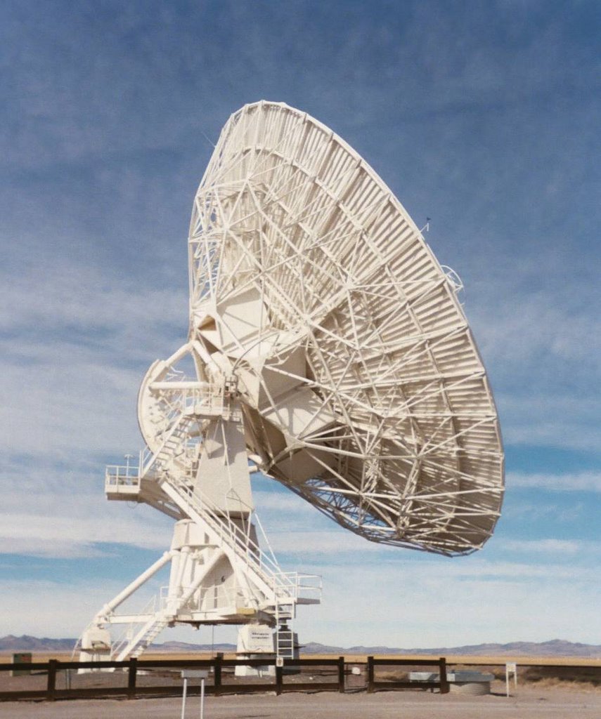 Wow! What a place! In the empty, silent Plains of San Augustin of western NM - Voila! The VLA (Very Large Array) radiotelescope dishes, arrayed on rails across the grassland like a peace symbol (on three sets of rails, each set 120 degrees apart from one another, kind of like a bird footprint). The VLA is an important part of the global VLBA (Very Large Baseline Array). A portion of the movie "Contact," starring Jodie Foster, was filmed here. (Photos from 2006.)
The antennas swung from the SW sky to the eastern sky over the space of an hour or so.

We can hear you, but we can't understand you!


Westgate Hotel and vicinity, 3000 Paradise Rd. Las Vegas, NV. According to the Apple podcast, the gambling scene was set in Elvis' old bedroom there ("Pluribus," Season 1, episode 6, 'HDP').
According to the Apple podcast, the John Cena presentation was filmed in Tampa, FL ("Pluribus," Season 1, episode 6, 'HDP').

Highway 6, southwest of Albuquerque (34.892383°, -107.081808°) ("Pluribus," Season 1, episode 7, 'The Gap').

Highway 6, not far from where Manousos drives, and near a filming location for "The Host" (2013), starring Saoirse Ronan.
.

Highway 6, not far from where Manousos drives, and near a filming location for "Outrageous Fortune" (1987), starring Bette Midler.


Manousos sets car afire - Podcast says car was set afire in PECOS, of all places! The town and area of Pecos is generally the entrance to the Pecos Wilderness, the terminus of a number of trails. Presumably they are at one of those places ("Pluribus," Season 1, episode 7, 'The Gap').
Manousos collapses - Podcast says that Manousos collapses in Spain (presumably in the Canary Islands) but the helicopter arrives when he is in New Mexico ("Pluribus," Season 1, episode 7, 'The Gap').

Peruvian Village - This location is driving me nuts. The Official Apple Podcast states that this location is in the vicinity of Pecos, NM, but it's very hard to locate. All the mountain peaks are CGI, presumably by Rodeo in Montreal, so there aren't many reliable visual clues. And Pecos is a perfect warren of secret places. Still, it's important to resolve this location, because Manousos' journey is partly in Pecos too. Based on a YouTube video of behind-the-scenes footage of the scene, I'm thinking (35.548253°, -105.667231°) is a possibility, but I'm not certain, because I would expect to see ground markings on the Google Earth image (taken shortly after filming would have ended), and I don't see anything. ("Pluribus," Season 1, episode 9, 'La Chica o El Mundo').


Airstrip - I think this is the Moriarty, NM airport; specifically the western end, where the big "8" is painted on the tarmac (34.982262°, -106.016957°) ("Pluribus," Season 1, episode 9, 'La Chica o El Mundo'). The mountains are artificial - done by Rodeo in Montreal.
Beach - ? ("Pluribus," Season 1, episode 9, 'La Chica o El Mundo').
NYC - ? ("Pluribus," Season 1, episode 9, 'La Chica o El Mundo').
Ski Lift Gondola - This is at the brand-new Explorer Gondola Base at the Big Sky Ski Resort in Montana (45.286008°, -111.402200°) ("Pluribus," Season 1, episode 9, 'La Chica o El Mundo').
Ski Lodge Room - According to the Apple Podcast this place is a restaurant - "One and Only Moonlight Basin Restaurant," Big Sky Resort, 77 Roosevelt Rd., Big Sky, MT 59716 (45.322833°, -111.428575°) ("Pluribus," Season 1, episode 9, 'La Chica o El Mundo').
Wish List of Undetermined Locations (Lista de Deseos de Ubicaciones Indeterminadas)

Near rug shop - ? - Presumably near the other sites, near Calle Nilo? ("Pluribus," Season 1, episode 2, 'Pirate Lady')

Setup for Boeing 747 Door - Was this near Albuquerque, or was it somewhere else, like Davis-Monthan AFB boneyard or Marana boneyard, near Tucson, Arizona? ("Pluribus," Season 1, episode 2, 'Pirate Lady')

'("Pluribus," Season 1, episode 5, 'Got Milk').

("Pluribus," Season 1, episode 5, 'Got Milk').

Lit street - I'm beginning to wonder if this is a studio shot. I'm having trouble finding such a location in Las Palmas. ("Pluribus," Season 1, episode 6, 'HDP')

Seashore - ? - Maybe Gran Canaria ("Pluribus," Season 1, episode 7, 'The Gap').
Rain - ? - ("Pluribus," Season 1, episode 7, 'The Gap').

Drive in city - ? ("Pluribus," Season 1, episode 7, 'The Gap').
(on map, Huaquillas)
Jungle - near Cascada de los Tilos? ("Pluribus," Season 1, episode 7, 'The Gap').
Manousos sets car afire - Podcast says car was set afire in PECOS, of all places! The town and area of Pecos is generally the entrance to the Pecos Wilderness, the terminus of a number of trails. Presumably they are at one of those places ("Pluribus," Season 1, episode 7, 'The Gap').

Manousos collapses - Podcast says that Manousos collapses in Spain (presumably in the Canary Islands) but the helicopter arrives when he is in New Mexico. ("Pluribus," Season 1, episode 7, 'The Gap'). Exact locations for both not yet known.

Panamanian Hospital - Don't have this one yet ("Pluribus," Season 1, episode 8, 'Charm Offensive').
Peruvian Village - This location is driving me nuts. The Official Apple Podcast states that this location is in the vicinity of Pecos, NM, but it's very hard to locate. All the mountain peaks are CGI, presumably by Rodeo in Montreal, so there aren't many reliable visual clues. And Pecos is a perfect warren of secret places. Still, it's important to resolve this location, because Manousos' journey is partly in Pecos too. Based on a YouTube video of behind-the-scenes footage of the scene, I'm thinking (35.548253°, -105.667231°) is a possibility, but I'm not certain, because I would expect to see ground markings on the Google Earth image (taken shortly after filming would have ended), and I don't see anything. ("Pluribus," Season 1, episode 9, 'La Chica o El Mundo').

Beach - ? ("Pluribus," Season 1, episode 9, 'La Chica o El Mundo').

NYC - ? ("Pluribus," Season 1, episode 9, 'La Chica o El Mundo').

Localizaciones de Rodaje en España (Spanish Filming Locations)
Lugares de Rodaje de la Temporada 1 por Provincia, Región o Isla (Season 1 Filming Locations By Province, Region, or Island)
España Peninsular
Biscay

Airport at Bilbao, Spain - According to Atlas of Wonders: The "establishing shot was filmed at the real Bilbao Airport in the Basque Country, designed by the renowned Valencian architect Santiago Calatrava." ("Pluribus," Season 1, episode 2, 'Pirate Lady')
Asturias

"However, the interior was filmed at the Oviedo Congress and Exhibitions Center in Asturias, designed by the same architect." ("Pluribus," Season 1, episode 2, 'Pirate Lady')

Estate in northeastern Spain - Getaria, Basque Country - Iturregi Hotela, 20808 Askizu, Gipuzkoa, Spain. ("Pluribus," Season 1, episode 2, 'Pirate Lady'; episode 9, 'La Chica o El Mundo')
Islas Canarias (Canary Islands)
Provincia de Las Palmas - Isla Gran Canaria - Las Palmas de Gran Canaria

Approximate location of Car Crash - Las Palmas de Gran Canaria, Barranca Guiniguada (28.102771°, -15.429149°) ("Pluribus," Season 1, episode 2, 'Pirate Lady')

Zosia climbs on motorbike - up above from previous site? - C. Cruz de Piedra ("Pluribus," Season 1, episode 2, 'Pirate Lady')

Painted pavement - Calle Nilo (28.104666°, -15.422091°) ("Pluribus," Season 1, episode 2, 'Pirate Lady')
Near rug shop - ? - Presumably near the other sites, near Calle Nilo? ("Pluribus," Season 1, episode 2, 'Pirate Lady')

Motorbike descends towards port - C. Sierra Nevada (28.104243°, -15.424704°) ("Pluribus," Season 1, episode 2, 'Pirate Lady')

Coastal drive pedestrian overpass (28.067770°, -15.417158°) ("Pluribus," Season 1, episode 2, 'Pirate Lady')

Manousos talks with his 'mother' - Las Palmas de Gran Canaria. Intersection of C. Real del Castillo and C. Gobernador Marín Acuña (28.101797°, -15.423640°) ("Pluribus," Season 1, episode 6, 'HDP')

Hospital Perpetuo Socorro (HPS Private Hospital), C. Pdte Alvear, Las Palmas de Gran Canaria, Spain (28.137210°, -15.430486°) ("Pluribus," Season 1, episode 7, 'The Gap').

Seaside Drive 1 - Kilometer 3 (28.089321°, -15.703299°) ("Pluribus," Season 1, episode 7, 'The Gap').

Seaside Drive 2 - Manousos' car is at (28.091650°, -15.706444°) ("Pluribus," Season 1, episode 7, 'The Gap').

Seaside Village - Camino Bajada de Caleta, Gran Canaria (28.162603°, -15.681881°) ("Pluribus," Season 1, episode 7, 'The Gap').

Gabinete Literario, Pt. de Cairasco, Las Palmas de Gran Canaria (28.102873°, -15.416567°) ("Pluribus," Season 1, episode 7, 'The Gap').
Provincia de Santa Cruz de Tenerife - Isla La Palma

Manousos walks with Empty Gas Can (28.797610°, -17.785030°) ("Pluribus," Season 1, episode 7, 'The Gap').

"How About Some Water?" (28.797640°, -17.785415°) ("Pluribus," Season 1, episode 7, 'The Gap').

Driver Leaves (28.797550°, -17.785909°) ("Pluribus," Season 1, episode 7, 'The Gap').

House with Spanish Tile Roof (28.796851°, -17.784307°) ("Pluribus," Season 1, episode 7, 'The Gap').

Manousos on Bridge filmed from about here (28.796756°, -17.781169°) ("Pluribus," Season 1, episode 7, 'The Gap').

Bridge - (28.797112°, -17.780979°) ("Pluribus," Season 1, episode 7, 'The Gap').

Steep street - Calle Cardón, Tazacorte, La Palma (28.643501°, -17.932031°) ("Pluribus," Season 1, episode 7, 'The Gap').

Church - Santuario de Nuestra Señora de Las Angustias - La Palma, Islas Canarias ("Pluribus," Season 1, episode 7, 'The Gap').

Tilos Bridge, La Palma

Manousos Drives (28.798464°, -17.777770°) ("Pluribus," Season 1, episode 7, 'The Gap'). "The Girl Saves the Mouse from the Trap"

Waterfall - Cascada de Los Tilos ("Pluribus," Season 1, episode 7, 'The Gap').
Jungle - near Cascada de los Tilos? ("Pluribus," Season 1, episode 7, 'The Gap').
Manousos sets car afire - Podcast says car was set afire in PECOS, of all places! The town and area of Pecos is generally the entrance to the Pecos Wilderness, the terminus of a number of trails. Presumably they are at one of those places. ("Pluribus," Season 1, episode 7, 'The Gap').
On Watch For Hopi Connections
In "Better Call Saul," Kim Wexler was associated with the Hopi God Panaiyoikyasi (Short Rainbow). Does that strong association also extend to Carol Sturka in "Pluribus"?

Carol is wearing a sweatshirt with a spruce tree on it, suggesting the sacrifices of Summer Solstice, but that doesn't seem to make much sense here ("Pluribus," Season 1, episode 5, 'Got Milk').


This particular view calls to mind a Spring Equinox marker - a circle with a point (in this case, pointing down from the ceiling). Only 60 days have elapsed in the Pluribus timeline, but the Hopi Ceremonial Calendar is not really tied to the show timeline - it stands alone. I'm guessing the show moves faster than either "Breaking Bad" or "Better Call Saul" did. See my post on the Hopi Ceremonial Calendar.
Hahai Wuhti
Are there any Hopi gods, kachinas, or people that might be comparable, in one sense or another, with Carol Sturka? After all, Kim Wexler was linked with Hopi god Panaiyoikyasi (Short Rainbow).
I'm thinking possibly the Kachina Hahai Wuhti (Katsina Mother) might fit Carol Sturka. Hahai Wuhti is one of the most talkative kachinas - perhaps the most talkative, in her high-pitched, sing-song falsetto (also called "Tongue Always Going"). Carol Sturka is notably loud and talkative.

Hahai Wuhti is known for several aspects, for example, as "Pour Water Woman," as well as "Kachina Mother," and "Kachina Grandmother." ("Pluribus," Season 1, episode 2, 'Pirate Lady')

Pouring vodka here. The chair backs are intriguing. Reminiscent of upside-down Crow Mother wings. ("Pluribus," Season 1, episode 3, 'Grenade Lady')

"Pour Water Woman." ("Pluribus," Season 1, episode 2, 'Pirate Lady')

"Pour Water Woman." ("Pluribus," Season 1, episode 8, 'Charm Offensive')

"Pour Water Woman." ("Pluribus," Season 1, episode 8, 'Charm Offensive')

Hahai Wuhti is also known as the "Mother of Dogs." ("Pluribus," Season 1, episode 5, 'Got Milk')

"Mother of Dogs." ("Pluribus," Season 1, episode 5, 'Got Milk')

"Mother of Dogs." ("Pluribus," Season 1, episode 7, 'The Gap')


Buffalo are the single-most important animal to Plains Indians, but given their large appetites they were rarely seen out in Hopi country desert country, and thus less important out there. Is there any connection to the White Buffalo kachina? ("Pluribus," Season 1, episode 7, 'The Gap')
Cannibalism
Hahai Wuhti's connection with cannibalism is complicated She is the mother of the two Nataska ogres. At Powamu, all three of them travel about and threaten to eat the children of the village in a ritual designed to strengthen family bonds. There are also a group of giants, the Soyoko, who were persuaded by witches at Oraibi to eat village children. The Soyoko were eventually fooled in a subterfuge by the War Twins, to eat their own children instead. (source: "Hopi Kachinas: History, Legends, and Art", Ron and Bob Pecina, Schiffer Publishing Ltd., Atglen, PA, 2013).
So, the theme of cannibalism in Pluribus may well derive from the Hopi, but it is expressed much differently in Pluribus than the Hopi do in their legend.
There is a curious moment in the script of "Got Milk" where the absence of children is noted when Carol makes her video where she talks about milk cartons::
Carol Sturka here with an update.Here where I live, Albuquerque, New Mexico, they drink this like it's going out of style.Th-These are little milk cartons, the kind we give children in elementary schools.Back when we had elementary schools.And children.
So, where are the kids? Are they being eaten, in a manner similar to Hopi legend?
Conclusion
